With the rapid development of science and technology, the aerial photogrammetry technology and laser radar mapping technology based on multi-rotor UAV are widely used in all walks of life in society. Multi-rotor UAV measurement under the concept of "UAV+" The surveying and mapping system is developing rapidly in the direction of automation, intelligence, comprehensiveness and high efficiency. It has been widely used in large-scale topographic surveying, cadastral mapping, forest surveying and mapping, and island reef surveying. It is a national bridge engineering construction and water conservancy project. Construction, power grid engineering construction, underground ground pipe network construction, smart city construction, smart port construction, tourism resource big data management, natural resource exploration, real estate management, land and resources survey and other industries provide accurate measurement mapping data and efficient Measuring and mapping means.
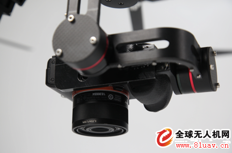
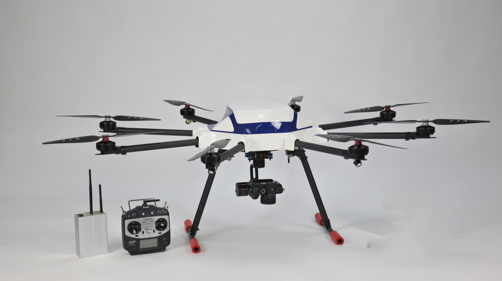
Tiantu Aviation Eight-rotor UAV aerial photogrammetry system and lidar mapping system can quickly acquire data from topography and surface appendages from low altitude. With powerful internal data production capacity and processing technology, it can be more efficient. More objective, more realistic, more stereoscopic, more accurate measurement and mapping, compared to traditional manual measurement mapping technology, based on aerial photography technology and laser radar mapping technology of drone, its measurement and mapping cycle is shorter and lower cost. The personnel are safer and the technical advantages are more obvious.
Second, the multi-rotor UAV aerial photogrammetry technology has four advantages over other measurement and mapping technologies
1 , rapid response and deployment capabilities
The Tiantu Eight-rotor UAV aerial photogrammetry system and the multi-rotor UAV lidar mapping system make full use of the characteristics of the multi-rotor UAV's low-altitude flight operation and the relatively convenient application of the airspace application, by installing a fiberglass waterproof head. The hood has strong ability to adapt to different meteorological conditions, and has less requirements and restrictions on landing and landing sites. It uses full autonomous routes to fly, and compared with traditional manual measurement mapping technology, the work intensity and operational risk of the field personnel are greatly reduced. In areas with harsh environments, UAV aerial photogrammetry technology and UAV lidar mapping technology can fully solve the high-risk environmental operation problems that cannot be realized by manual surveying and mapping. In emergency rescue and disaster reduction missions, UAV aerial photography Measurement technology and UAV laser radar mapping technology, its rapid response and deployment capabilities have a huge advantage compared with traditional manual measurement mapping technology, its personnel occupation is less, the preparation time for launching is shorter, and skilled operators can realize the scene. Less than 15 minutes of rapid take-off, Tiantu Eight-rotor UAV aerial photogrammetry system, its
2 , outstanding timeliness and cost-effective advantages
Traditional manual measurement mapping technology generally faces two problems. The first is that the update period of archived data is longer, and the second is that the cost of data update is higher.
Tiantu Eight-rotor UAV aerial photogrammetry system can solve this problem well. Data acquisition personnel can start at any time, shoot at any time, and prepare time is shorter. Compared with manual measurement mapping technology, it can be completed quickly in a short time. Large-scale data acquisition work, timely provide users with the required data results, and because of the lower cost of data acquisition, compared to traditional manual measurement mapping technology, UAV aerial photogrammetry technology will become a small range measurement in the future. The development trend of surveying and mapping.
3 , the flight height is low, less restrictive factors
Our country is vast in area, and its topographical conditions and climatic conditions are complex. Many areas are affected by snow and clouds all the year round, which has led to certain restrictions on the collection of satellite remote sensing data, while the traditional large aircraft is subject to national The relevant regulations and clear restrictions on meteorological conditions, such as flying height is too high, will inevitably be affected by the cloud layer, hindering the quality of mapping, such as poor meteorological conditions, data acquisition can only be stagnant indefinitely, greatly increasing the data Obtaining the time of the operation, direct imaging to the cost of data acquisition operations, and serious flight safety problems in border areas and sensitive areas, while the Tiantu Eight-rotor UAV aerial photogrammetry system, because of the flight speed of the UAV Slow, low flying height, small size, battery powered, low social harm, that is, it overcomes some limited problems well, and its low-altitude imaging quality and later data accuracy are far superior. Aerial film quality and data accuracy that can be achieved by large aircraft.
4 , a wealth of measurement mapping data types
Tiantuo multi-rotor UAV aerial photogrammetry system can quickly acquire a large number of topographical features and surface appendage information when using strong wind and long-haul, and use the high-resolution digital image and post-difference positioning data obtained by the ground to combine with the ground. Control point data can generate high-precision DOM data, DSM data, true 3D real-world model data, point cloud data, and DLG digital line graph data, which is convenient for later application system development and big data integration under various conditions. The traditional digital surveying and mapping technology has a single digital line drawing result. The drone aerial photogrammetry technology brings rich, high-precision and different types of data results, with more intuitive visual impact, rich in More information elements, easier to interpret, and a wider range of applications.
Perfect fit: The Hydrogel Screen Protector is designed with a Soft TPU material, which can be completely covered even on a curved device, providing perfect protection for the full coverage of the screen.
Oleophobic and waterproof: The use of hydrophobic and oleophobic screen coatings can prevent sweat, grease residue and fingerprints without reducing screen sensitivity. It is almost invisible on the screen and brings a high-definition visual experience.
Sensitive touch: ultra-thin and Soft Hydrogel Film with a thickness of only 0.14mm. As time goes by, it will Self-repair minor scratches, provide you with a highly responsive screen protector and maintain the original touch.
Easy to install: The installation of the Protective Film is very simple, without air bubbles. The protective sticker can stay on the phone perfectly, and the bubbles will disappear within 24 hours.
If you want to know more about Hydrogel Screen Protector products, please click the product details to view the parameters, models, pictures, prices and other information about Hydrogel Screen Protective Film.
Whether you are a group or an individual, we will try our best to provide you with accurate and comprehensive information about the Hydrogel Protective Film!
Hydrogel TPU Protective Film,Ultra-Thin Protective Film,Soft Hydrogel Film,Hydrogel Film Screen Protector,Screen Protective Film,Mobile Phone Screen Guards
Shenzhen Jianjiantong Technology Co., Ltd. , https://www.jjthydrogelmachine.com