(Original title: Scientific and technological disaster relief, human-robot collaboration of "human flesh algorithm" is the future trend)
澎湃 News Contributing Author Ren Wei
Did the natural disaster strike and did humans have sufficient ability to alert or respond to the disaster?
The answer is yes. The question is: How effective can this ability to manage disasters be with science and technology?
Technology Relief from Data Map to Disaster Broadcast Robot
According to a 36-inch report, the first warning message before the Jiuzhaigou earthquake came from the research and development of the Chengdu High-tech Zone Disaster Reduction Research Institute head Wang Hao and his team, and the ICL earthquake warning system jointly established with the Sichuan Aba Prefecture Earthquake Disaster Reduction Bureau. 71 seconds in advance through the mobile phone and a dedicated terminal for warning information for the city of Chengdu, and 19 seconds ahead of time issued an early warning for Weinan City of Gansu. Another news from the China Seismic Network that the first time after the disaster, the release of the disaster news came from the "earthquake information broadcast robot" that they had independently developed since 2015. In 25 seconds, they wrote more than 500 words and accompanied 5 seismic information maps. The first time broadcasts seismic information on multiple platforms and can cover hundreds of millions of people in one minute.
Technology relief is not uncommon in the past 10 years. Back in 2007 after the Peruvian earthquake in 2007, IBM developed an open-source software Sahana (Sahara) to distribute all types of disaster information on the map in the form of digital maps, so that the rescuers can obtain information on the disaster situation at the first time.

Open source software Sahana (Sahara)
In the 2008 Wenchuan earthquake, Baidu quickly went online on the third day after the earthquake. “Wenchuan Earthquake Seeks for Peopleâ€. The forum was mainly used to post information on the rescue of the affected people.
After the earthquake in Haiti in 2010, Google launched Google's search tool and provided satellite cloud maps, shelters, traffic information, and power information in multi-language collaborative work. Following the Rio de Janeiro flood and mudslide disaster in 2010, the city used IBM's R&D city operations center to manage all crisis data.
In 2013, IBM launched a new smart city operation center to further strengthen crisis management capabilities in a smart city environment.

IBM's Smart City Operations Center, Image from IBM's official website
IBM's "Intelligent Operations Center" provides a "hypothetical" operating model that performs a pre-test on the follow-up effects of certain types of emergency management.
The Humanitarian Open Street Map Team, a humanitarian open street map established in 2011, is a volunteer network that uses a network of volunteers to conduct data crowdsourcing. It recruits volunteers to conduct real-time disaster relief, information release and drawing on the Open Street website. .

Humanitarian Open Street Map
In 2012, The Rapid Family Tracing and Reunification System (RapidFTR), an open source software jointly developed by technology company Thoughts Work and UNICEF, was used in refugee camps in Uganda to help find children who lost their lives in the disaster. The aid agency is able to enter child information on the mobile phone and track it geographically so that parents who lost the child can use the database to find the child they lost during the disaster.
In the Yaan earthquake in 2013, the Yiyun Disaster Relief Map effectively coordinated the disaster relief needs and disaster relief resource information in real time, released a map of digital disaster relief information, and combined maps with on-line demand and resources for manual matching, through the “manual data cleaning†of volunteer teams. The information on the disaster situation in the social media that was originally intermingled with massive prayers, emotions, and disaster inquiries was accurately extracted and accurately targeted on the digital map to help the first-line disaster relief team to discover the situation in time. Dead zone.

Yiyun Disaster Relief Map
On April 25, 2015 earthquake in Nepal, Dajiang sent staff to teach the local people to use the Phantom Phantom 3 to draw a map of the village. They quickly acquired the local 3D map, and quickly calculated the damage status and specific locations of the building.
On June 7, 2017, the facebook research institute announced facebook's “Relief Map†on the line. Through the three data sets “density mapâ€, “motion map†and “safety confirmation mapâ€, real-time display of population density and population flow in the disaster-affected area after the disaster. Tracks and confirmed disaster safety information. Facebook's global users have become “human flesh data sensors.†All face book users who come into contact with disaster information at the first time can become disaster relief data volunteers and invest in disaster data collection. After the data is collected by Facebook users, Facebook will use "time aggregation", "spatial aggregation", "spatial smoothing" and other data algorithms for analysis and visual presentation on the map page.
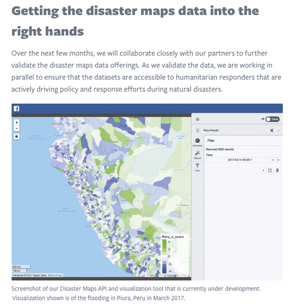
Facebook "Relief Map", image from Facebook Academy official website
The Zhuoming Disaster Information Service Center, which has served for many years in the field of disaster relief, has also drawn the “Map of the Social Organization Action of the 7.0 Earthquake in the Jiuzhaigou Valley in Sichuan Province in 2017†by volunteer crowdsourced data, as shown below:
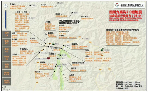
2017 Sichuan Earthquake 7.0 Earthquake Earthquake Social Organization Action Map
Human factors algorithm in disaster relief
Disaster relief is a human-oriented humanitarian aid that requires much. Every time science and technology help disaster relief, people's participation cannot be separated.
More and more emerging scientific and technological means are used in disaster relief and post-disaster relief operations. When we can already perform earthquake warnings and report earthquake disasters through artificial intelligence algorithms, how can hi-tech technologies provide timely and effective services to disaster relief teams? The improvement of the effectiveness of disaster relief and emergency management has become the most important issue in the current smart urban and rural management.
If the occurrence time and magnitude of the earthquake can be monitored by the source monitoring instrument, the news about the earthquake can be broadcasted in real time through a text analysis algorithm. However, in the disaster relief process, people’s needs, actions and resources are allocated, and the rescue team The physical and health-related person data in action are difficult to monitor in real time. These data related to people need to pass through third-party human sensors, such as data map volunteers and first-line disaster reporters, and collect and collate data through on-site observations and records and upload them to the cloud. , to assist disaster relief decisions. When technology disaster relief becomes the mainstream discourse, due to its dependence on disaster relief hardware and software, it often overlooks the importance of user experience and disaster relief data management for disaster relief data tools.
The author once served as the leader of the Yayun disaster relief map data volunteer team during the Ya'an earthquake. During the crowdsourcing process of Ya'an disaster relief map, the author discovered that the disaster relief team will not adopt the new digital disaster relief tool at the first time. In a time-critical environment, they often use their trusted and familiar communication tools for disaster relief communication, such as sending messages in a QQ group that is sufficiently familiar with information collectors, or directly communicating with disaster relief partners via telephones, etc. Wait. Under this circumstance, the "forced insertion" of scientific and technological disaster relief tools has not only failed to "install" to the disaster relief site, but it has been difficult for the science and technology disaster relief tools to play an effective role in helping them to become the burden of first-line disaster relief personnel.
Also in the process of Ya'an Information Relief, WeChat Group also played an important role in information relief. Disaster relief team members, volunteers, local people, and the WeChat group quickly gathered together to maximize information stacking. However, due to the overly convenient information release, there is no artificial information flow control for the format, rhythm, and data volume of information dissemination and dissemination. The more crowd-based WeChat groups, the “information flood†caused by information overload frequently occurs, and it is difficult for disaster relief teams. Finding useful information in these "data mudslides" has resulted in the inability of timely matching of demand and disaster relief resources and delays in disaster relief.
In the final analysis, technology tools are used for disaster relief. The core users are disaster victims and disaster relief actors. If technology tools ignore the user’s data, time, and affordability of communication effects in data collection, data transfer, and data management, the technology disaster recovery tool is either not abandoned by the user or is not accurately collected for decision-making. As a result, "digital disaster relief secondary disasters" have been accompanied by the use of technology tools.
Therefore, given the user experience of first-line disaster relief team members using technology disaster relief tools, the scientific effectiveness of scientific and technological disaster relief tools can be better utilized. On August 18th, 2014, the “8.03 Ludian Information Relief User Experience Workshop†of Sichuan University-Hong Kong Polytechnic University Disaster Recovery Institute and Yiyun Map Cooperation, the volunteers from various institutions who participated in Ludian disaster relief rushed to the Tucao Weixin Group. The information on Weibo was overloaded. At that time, many organizations had issued their own disaster relief briefings to publicize the public interest. However, the information provided by the disaster relief agencies was accurate and accurate, and the scope and trajectory and trends of the disaster relief teams were almost invisible. The disaster relief team was miserable for the cumbersome and excessive information.
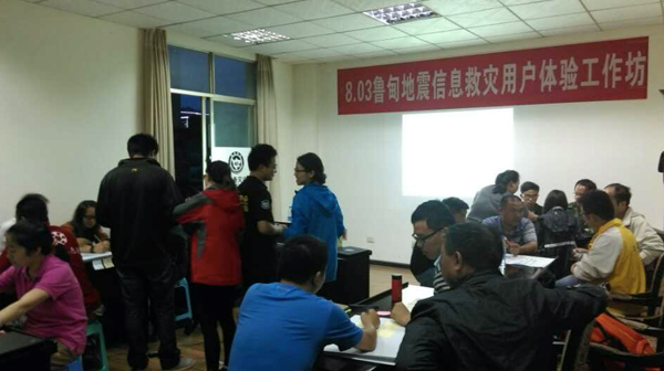
August 18th, 2014, "8.03 Ludian Information Relief User Experience Workshop" of Sichuan University-Hong Kong Polytechnic University Post-disaster Reconstruction Institute and Yiyun Map Cooperation
An essay from the Pakistan-based National University of Science and Technology Zoha Sheikh et al. published at the 14th International Conference on Crisis Response and Management Information Systems, User-Assisted Information Extraction from Twitter During Emergencies, clearly listed during the disaster, through user assistance Extract the entire text of the text of the twitter disaster, the original text from the unmarked text to the precise text of the output annotation.
In the process of text labeling, due to the different understanding and classification of texts by different standard staff, the text attributes are often marked differently. Therefore, the information of the disaster information presented will be different. In case of mislabeling, you need to use twitter. User-assisted labeling to correct the occurrence of machine learning algorithms for disaster scenarios. This shows that machine learning algorithms are not foolproof and need to be managed and adjusted through the user's actual experience and knowledge.
Taking the map of the digital disaster relief map of the Ya'an earthquake in 2013 as an example, a real-time and accurate digital disaster relief map is drawn. From the volunteer's overall planning, data collection, sorting, cleaning, release, action decision-making, to action feedback, a comprehensive guarantee is needed. Timeliness of disaster relief information, timely dissemination, authenticity of data, communication and dialogue mechanisms of data collectors, smooth flow of data channels, and data security for disaster relief information. These people's management, use, and feedback of scientific and technological disaster relief tools are "Human Algorithms" other than software and hardware for disaster relief tools.
This kind of human factor algorithm mainly refers to a human-machine collaboration mechanism that the user invokes and coordinates technology tools to make behavioral decisions according to their own experience, usage habits, and specific usage scenarios. In the movie "Sali Captain", Captain Sally judged the return landing location based on his years of flying experience, and rejected the return route recommended by the aircraft's artificial intelligence navigation system. Captain Pail’s experience in judging this is that at a critical moment, he launched his “Human Factors Algorithm†and made critical emergency decisions.
A new plan recently announced by Google “People +AI research†- PAIR plan is to place human subjective decision-making mechanism - human factor algorithm, at the core of human-computer cooperation model research. , thereby reducing the negative effects of artificial intelligence and improving the efficiency of human-computer cooperation.
It can thus be seen that under the human-computer collaborative work environment, people and technology tools have become a whole, but this whole is based on human decision-making as the core.
Disaster relief tools for science and technology, whether it is data maps or artificial intelligence disaster robots, these technological tools are the “digital exoskeletons†of disaster relief teams in the crisis situation of emergency relief and post-disaster resettlement. These tools are carried around and worn. The disaster relief team's correctness of the authenticity and effectiveness of data collection and the correction of machine learning algorithms for disaster analysis are all complementary to humans, rather than the human decision-making.
Especially in times of crisis when the environment is changing, the time is tight, and resources are limited, the disaster recovery team is faster, more accurate, and more intuitive than the machine algorithm for gathering and judging the first-line data. The design and use of technology disaster relief tools need to consider the use of digital tools for disaster relief team members in specific scenarios to enhance the user experience of disaster relief team members using digital tools in the field. It is truly scientific and accurate disaster relief.
Relief through science and technology is playing an increasingly important role in smart urban and rural management. However, scientific and technological disaster relief is not only the hardware and software part of the disaster relief tool for science and technology, but also the collaborative work between humans and science and technology intelligent disaster relief tools, and the impact of human behaviors and attitudes on disaster relief data, and the evaluation and acceptance of algorithmic recommendation decisions by humans. The "soft nuclear science" in smart city emergency management is the content of smart urban and rural emergency management. Existing smart urban and rural emergency management systems often only value the contribution of technology tools, and they neglect the participation and contribution of human factor algorithm in the whole process of information management in emergency management.
Only by fully integrating the contribution of humans in the disaster relief process with the technical disaster relief tools, the human factor algorithm, will be incorporated into the core position of the smart city emergency management to maximize the science and technology to aid the scientific effectiveness of disaster relief and be armed with technology tools. The disaster-relief team members and city administrators can truly work together to open up front-line and rear-side collaborations, and truly achieve human-machine collaboration and people-oriented disaster relief.
ZGAR AZ CC Disposable
ZGAR electronic cigarette uses high-tech R&D, food grade disposable pod device and high-quality raw material. All package designs are Original IP. Our designer team is from Hong Kong. We have very high requirements for product quality, flavors taste and packaging design. The E-liquid is imported, materials are food grade, and assembly plant is medical-grade dust-free workshops.
Our products include disposable e-cigarettes, rechargeable e-cigarettes, rechargreable disposable vape pen, and various of flavors of cigarette cartridges. From 600puffs to 5000puffs, ZGAR bar Disposable offer high-tech R&D, E-cigarette improves battery capacity, We offer various of flavors and support customization. And printing designs can be customized. We have our own professional team and competitive quotations for any OEM or ODM works.
We supply OEM rechargeable disposable vape pen,OEM disposable electronic cigarette,ODM disposable vape pen,ODM disposable electronic cigarette,OEM/ODM vape pen e-cigarette,OEM/ODM atomizer device.


Disposable E-cigarette, ODM disposable electronic cigarette, vape pen atomizer , Device E-cig, OEM disposable electronic cigarette
ZGAR INTERNATIONAL TRADING CO., LTD. , https://www.szdisposable-vape.com