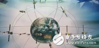
There is a tall club in the world. It has only four members, but it attracts the attention of heads of state and the research of many top scientists. The club is GNSS (Global Navigation Satellite System), and the four members are US GPS, Europe. Galileo GALILEO, Russia GLONASS GLONASS, China Beidou COMPASS.
China Beidou is a new member, and it is also the most powerful member of the development momentum. What is Beidou? What is the impact on our lives? This is a very interesting topic. There are many articles on academic journals about Beidou, but there are too many terms in professional articles, and ordinary people can't read them, and they are not interested in reading them.
On October 4, 1957, the Soviet Union launched the world's first artificial earth satellite, creating a space for human space. The United States is paying close attention to this. There is a mathematician named Bill Gay and a physicist named George Wienbach. They found a phenomenon in Hopskin’s Applied Physics Laboratory. The frequency of this satellite has shifted, and it has been found to be a Doppler shift effect caused by relative motion.
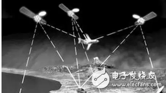
The two scientists conducted an experimental study and found that if multiple receivers are set up on the ground, the specific position of the satellite can be derived based on the different frequency differences of the received signals. They are happy to tell the results of this research. The laboratory director Frank. McClure said that they have achieved Doppler positioning tracking of Soviet satellites.
Director Frank was doing a study of the Navy at the time. The content of the study was how the Pentagon knew the specific location of the warships in the sea. After hearing the reports from the two scientists, he was bright, since you can find out where the satellite is, if you reverse the problem Come over, the satellite will find out where you are, and the problem of positioning the naval warship has ideas!
The GPS system was started according to this idea. The first problem that needs to be solved in the solution is: Which orbit should the satellite use low, medium and high? If low-orbit is used, the launch cost is relatively low and the accuracy is relatively high. However, if it covers the whole world, it needs 200 satellites, so the vast project can't afford it.
If high orbit is used, theoretically three satellites can cover the whole world, but in addition to the difficulty of launching high-orbit satellites, the main reason is that the positioning accuracy will be low for two reasons: First, the track is too high, which will lead to measurement. The error is large, and the second is that the relative velocity between the geostationary orbit and the ground object is small, which is not conducive to the solution method using Doppler frequency shift.
The medium orbit is a relatively compromise solution. It only needs 24-36 satellites to cover the whole world. Since the orbit is moving, even if the objects on the ground are not moving, the speed of the satellite is also large, which can make full use of the Doppler shift. The method is gone.
Based on the above comprehensive considerations, the United States chose the medium orbit constellation of 24 satellites. The first one was launched in 1978. The whole system was put into operation in 1995. There are 30 satellites in the existing military and civilian positioning modes, among which civilian use. The way is open to the world.
GPS is a good thing, and the quality of people's lives is greatly improved. For example, car and mobile navigation are very important. People say goodbye to the history of finding a way on a paper map. GPS is more important for adventure navigation, and critical moments can save lives. Such a good thing, the United States has invested a lot of money, actually free to the world, is the US government alive Lei Feng?
In fact, even if GPS is not free, it will not be able to collect money. Why do you say this? Because GPS is a one-way communication system, this is similar to a broadcast television tower. Everyone knows that the radio and television towers only transmit signals. In the end, there is one radio or 10,000 radios. The radio and television towers don’t know. The GPS system is also the same. The 30 satellites only send signals to the ground. Specifically, who is receiving and using these signals, it is completely unaware of it, since it is unknowing, how to collect money?
Can you collect money by selling high-priced decoder chips? The answer is no, because GPS uses a one-way communication mechanism that only sends out, which is a natural obstacle for encrypted transmission. Even if encryption is done, it will be cracked in a few days, especially the civilian code. Simple to use, the receiving device requires low cost, which is even more difficult for encryption.
If GPS is free, it will definitely form a huge market in the world. Relying on this system will generate a new international industry, and at the same time it will form a strong national soft power. Therefore, GPS free is in the national interest of the United States.
GPS is a welfare for the people's livelihood around the world, but it is a challenge in the military. Of course, the US military can be installed on the warships of the hostile countries. The Americans can't ban it. Is this a threat to the United States? In fact, the GPS is only open to the civilian code, the accuracy is ten times worse than the military code used by the US military, and it is concealed a lot. More importantly, if you have a fight with the United States, people will give you a GPS code, you are already relying on GPS, and even the compass is lost, this can be caught. If the United States does not stop GPS for you, but sends a scam code, the missile aimed at the United States may fly to its position, which is even more terrible.
Therefore, the armaments of other countries must not use the US GPS. Once the dependence is formed, they will be unable to extricate themselves like drug users. It is necessary to develop their own navigation system. Of course, the development of the country's positioning and navigation system is only the right of a few big powers. As for the small countries such as Thailand and Mexico, it is not necessary to exercise this kind of heart, because the global positioning navigation system is really too large, and the small countries with weak overall national strength simply do not make it. From now on, let's continue to use GPS, which is also worry-free.
3. The origin of the Beidou generationChina is an ambitious big country. It can't be saved in positioning navigation satellites. In fact, it has been troubled since the 1970s. The "New Four Stars" plan was proposed in the Seventh Five-Year Plan. Single-star, double-star, Samsung, three- to five-star regional system solutions, and multi-star global system vision. Research, argumentation, re-study, re-argument... never stopped.
In the early 1980s, the expert group headed by the "two bombs and one star" Yuan Xun Cheng Fangyun proposed a double-star positioning program, which was recognized as the optimal solution at the time, but was put on hold for ten years due to various economic reasons. 1991 was a major turning point. The Gulf War woke up the Chinese. The application of the US GPS in combat was very successful. The decision-makers realized that it was really impossible to fight this thing in the future. The double-star positioning scheme that was put on hold for ten years was Start now.
Why don’t you engage in a system of 30 satellites like the US? At that time, the national conditions were inexperienced and had no money. I just had a good start at the beginning. I started from a small fight, and it was easy to play the big pot when I came up. Some netizens will ask, can the three coordinates be positioned in space, and the two satellites are not enough? This is a good question. There is a height meter in the binary positioning scheme. The user needs to self-measure the elevation and use the result as the third coordinate. This is like installing a virtual satellite in the center of the earth, which realizes Samsung positioning. Then why not just launch three satellites? The reason is simple, the altimeter is cheap, and this solution is more economical.
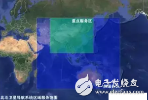
There are only two stars. Of course, we can't engage in orbit like the US GPS. The track has a low coverage. The two medium-orbiting satellites will fly outside China's space most of the time. What about China's mainland? Therefore, it is only possible to engage in high orbits, and it must be static so that it can be properly parked over the Chinese mainland.
Static high orbit is a must for dual-star positioning. Technically, this is undoubtedly correct, but it has buried hidden dangers of poor performance. This is the next question to be discussed. The Beidou generation was criticized.
We are professional audio manufacturing company that makes a variety of speaker with bluetooth, including bluetooth portable speaker, bluetooth speakers outdoor, small speaker bluetooth, light bluetooth speakers, waterproof speakers etc.
With full turnkey service from product design to delivery, and every step in between.
From sophisticated custom audio systems to 'off-the-shelf' speaker drivers, iTopnoo has been saving our customers time, effort, and money.
To constantly offer clients more innovative products and better services is our consistent pursuit.
Best Portable Speakers,customizable bluetooth speaker, Custom jbl speakers, speaker wholesalers
TOPNOTCH INTERNATIONAL GROUP LIMITED , https://www.micbluetooth.com